Automation and Images
For more than 10 years, we have been continually offering innovative technologies to our customers, supporting them in the development and transformation of scientific innovations into operational solutions.
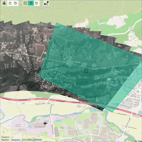
Optimised data capture
Our goal: to provide you with efficient, high-performance data production solutions
The rapid production of accurate data, from a wide range of sensors, is essential to the value chain our customers implement. We design, develop, manufacture and implement complex acquisition systems to meet our customers' specific needs. Drawing on the expertise of our doctors and engineers, we provide innovative, state-of-the-art solutions for the efficient production of quality data.
From the production of georeferenced aerial videos to the realization of a stereovision bench, via a LiDAR or hyperspectral perception system, our teams can meet all your needs.
Cutting-edge technologies
Design and production
Our expertise in sensors, optics, mechanics and electronics enables us to design and produce a tailor-made acquisition system.
Software products
We develop software and design data acquisition systems based on heterogeneous, synchronized and geo-referenced sensors.
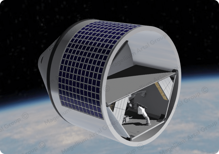
Payload integration
With the support of partners recognized in their fields, we integrate payloads on different types of carriers and validate their operation for optimum production.
Implementation
We support our customers in the data production phases with our acquisition methods and our airborne (rotary and fixed-wing UAVs) and ground-based (mobile platforms) resources.
Data quality
We draw on over 20 years' expertise in processing raw data to deliver reliable, useful data. Our systems produce qualified data.
Our references in this field
Colibri for CNES
Drone acquisition and image reconstruction to precise geometric and radiometric specifications
RAPID EYEPERION (R&D)
Design and manufacture of wide-field and 360° payloads
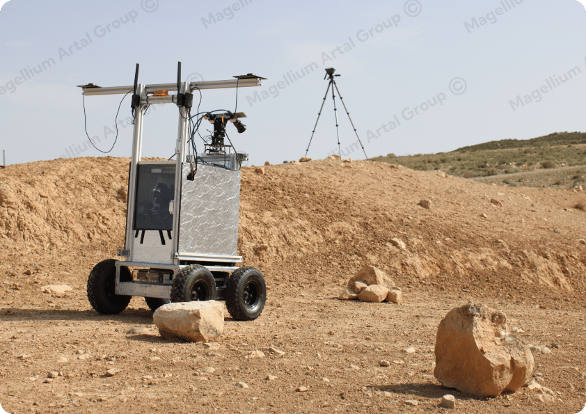
MOBILEX (ANR challenge)
Equipping a terrestrial robotic platform with sensors to provide autonomous navigation capabilities
Autonomous Mobility
LiDAR processing and data fusion for autonomous vehicle navigation
Data capture in a few images

Image and Video
Pixels for fast decision-making
Our teams develop hardware and software solutions forreal-time analysis of image and video data. Initially developed for the French army, our technologies now benefit civilian security forces, as well as any actor needing to intervene rapidly and in a targeted manner over large or difficult-to-access geographical areas.
Technology that efficiently meets your needs
Image processing
We develop data enhancement algorithms (e.g. image quality enhancement, software stabilization, anonymization, etc.).
Georeferencing
Our technologies are built on Magellium Artal Group's longstanding expertise in sensor geometry and digital geography, enabling optimal georeferencing of data.
Detection
Detecting changes, defects, objects, targets or postures, our solutions can extract all kinds of information from images or videos. We draw on our advanced expertise in image processing and artificial intelligence.
Real time
Our technology offers real-time video streaming capabilities, adapted to the target operational platforms.
Our references in this field
Cartonuit
Real-time drone mapping system with minimal logistical footprint for real-time monitoring of large forest fires
Lockeeper
Vision-based localisation system for UAV navigation in private GNSS environments
Road Mapper
On-board artificial intelligence for real-time mapping of street furniture elements
C-Track
Real-time video processing for military airborne intelligence
Some images of our tools
Robotics and 3D Simulation
From simulation to robotics in constrained environments
For over 15 years, our teams have been developing expertise in perception for planetary exploration robotics. This work has enabled us to contribute to renowned missions such as Rosalind Franklin Mission (formerly EXOMARS), Rosetta and MMX.
Today, we put our skills at the service of any critical robotics application requiring consideration of a complex or hostile environment (robotics in orbit, terrestrial navigation without GNSS, etc.). To achieve this, we deploy our robotic simulation solutions to create a digital twin of your system.
Comprehensive know-how for autonomous robotics missions
Perception and localisation
Our expertise in the field of heterogeneous data fusion for vision-based localisation has enabled us to develop high-performance relative and absolute localization solutions for complex environments that are not dependent on GNSS signals.
2D and 3D mapping
Our mastery of 3D data (LIDAR, Stereovision) enables us to offer a precise representation of a robot's environment, from the generation of 2.5D Digital Terrain Models (DTMs) to the complete representation of 3D environments.
3D processing and detection
We bring our skills in semantic analysis of the environment through terrain classification components for autonomous navigation, and object detection, recognition and tracking for more dynamic environments.
Simulation and Digital Twin
We are developing a solution to simulate a complex robotic environment to assist the end-user in sizing and designing a robotic mission. This tool can also be deployed as a digital twin to monitor operations in progress.
Our references in this field
ROSALIND FRANKLIN MISSION (ex-EXOMARS)
Development and validation of a technological demonstrator for autonomous navigation on Mars
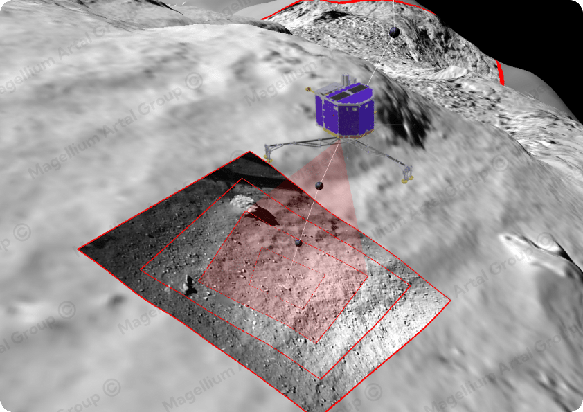
Rosetta
Vision-based localisation for PHILAE lander trajectory reconstruction
MMX
Perception and onboard autonomous navigation software for Phobos exploration
ADE/Corob-X
Perception and localisation for autonomous rovers exploring extreme conditions
PULSAR, ISAAC, DEMARLUS, EU-RISE
Definition and operational 3D simulation of autonomous in-orbit assembly missions
Some images of robotics
Space surveillance
Detecting and tracking space objects
Since 2015, we have been developing expertise and solutions in Space surveillance on the function of detecting and tracking space objects (satellites and debris), on the ground or onboard satellites.
A range of high-performance solutions
Classic algorithms
Custom development of detection and tracking algorithms, and state-of-the-art software inheritance of these functions
Artificial Intelligence
Deep learning, in competition with conventional methods, with work on denoising and detection.
From ground-based telescopes to satellite payloads
We bring our skills in semantic analysis of the environment through terrain classification components for autonomous navigation, and object detection, recognition and tracking for more dynamic environments.
Simulator development
Optical spatial scene simulator remarkable for its representativeness and versatility, invaluable for exploratory work, qualifying solutions, training neural networks and training operators.
Our references in this field
TAROT - CNES
We are responsible for the detection and tracking of space objects and debris, operational since 2015 on the TAROT telescope network.
EU SST
Development in 2020-2021 of the "high-fidelity" simulator and new functions for detecting and tracking space objects
CoS3 - CNES
France 2030 project operated by CNES. Working in partnership with ArianeGroup and Eutelsat, we are developing the spaceborne version of this object detection and tracking function.
Panoptès - Sodern
As a subcontractor of Sodern ArianeGroup, we are developing a tool for detecting and tracking intruders/debris from space, with an on-board function for real-time operation.
Some space surveillance images
Are you a C++ or Python developer? We'd love to hear from you!
We're looking for our future colleagues in a wide range of specialised engineering fields! Explore our many job opportunities and start a new chapter in your career with Magellium Artal Group.


Discover the many sectors of activity in which we operate
From space and defense to security, transport, energy, environment and climate, we are present in a wide range of sectors. Have you found your sector?
+150
customers place their trust in us
+10
different business sectors
FAQ
Do you offer turnkey solutions?
Yes, we offer not only a complete set of software functions, but also integrated, packaged solutions. This guarantees easy implementation and an optimised platform tailored to specific algorithms and operating conditions.
How are you positioned in the AI field?
Our approach to artificial intelligence at Magellium is unique. With over a decade of expertise, we distinguish ourselves by our pragmatic vision: instead of relying on massive data accumulation, we prioritise the rapid development of optimised neural networks. These networks are finely tuned to specific operational needs, even when data volumes are limited.
Can your functions be integrated into third-party software?
Absolutely. To meet the needs of certain customers without complicating user interfaces, we offer the possibility of integrating our functional suite seamlessly into our customers' software ecosystems.
What computing capacities are required?
Computing capacity requirements vary according to the number of functions to be operated simultaneously. We offer low-resource embedded solutions, ideal for integration as close as possible to the acquired signal, while minimising power consumption. For laboratory processing, we can dimension workstations to eliminate any limitations linked to the number of algorithms or sampling frequency.
Do you only process video data?
No, our expertise extends far beyond video. We specialise in analysing data from a variety of sensors, including Lidar, hyperspectral, IR and others. We georeference these data and process them using state-of-the-art technologies. Although visible video is frequently used in our systems, it is only one of several data sources we exploit.
Do you have any question?
We'll get back to you as quickly as the satellite data takes to reach the operator.
